

A Washington State ferry crossing Puget Sound at sunset, its windows lit, with the Olympic Mountains silhouetted against a coral sky.

Ferry Good

Where the boat actually is, how full the car deck is, and when you need to leave the house.

Download on the App Store Want it onAndroid?

Scan with your iPhone's camera to get Ferry Good.

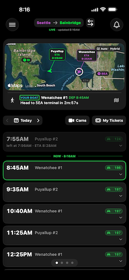
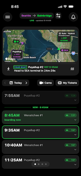
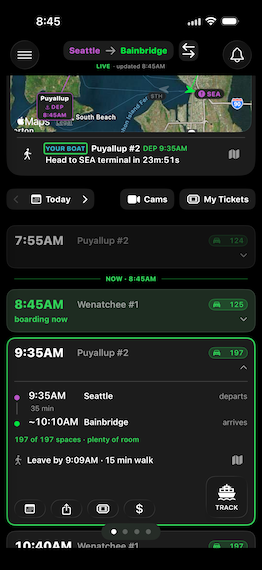
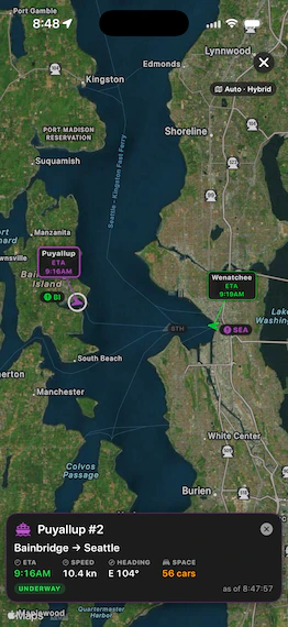
Ferry Good on Seattle to Bainbridge: the Puyallup and the Wenatchee crossing on the map, the Wenatchee's 8:45 AM sailing as Your Boat, and the morning's sailings with the car spaces left on each.

See it

Where the boat actually is

  1. One screen, honest answers

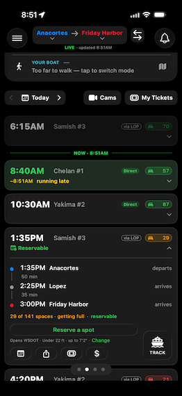
    On the map, each ferry is the color of the terminal it's headed to next. Under the map, Your Boat picks the next sailing you can make from where you are and counts down to when you need to leave, on foot, by bike, or by car. Below that is the day's schedule: car spaces left on each sailing, turning orange and then red as the deck fills, likely times in amber when a boat is running late, and cancellations struck through.

  2. Rotate the phone, the radar fills it

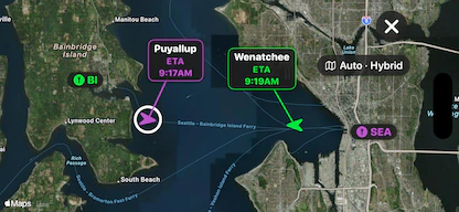
    Turn your phone sideways and the map fills the screen, framed from one terminal to the other, with the same leave and arrive times on each boat's flag. Pinch and drag to look around. Turn it upright again and you're back on the schedule. You can switch this off in Settings.

  3. Open a sailing

    Tap any sailing to open it: when it leaves and arrives, how long the crossing takes, how many car spaces are left, and WSF's notes. When you need them, it adds the time to leave by and directions in Apple Maps or Google Maps. Today's upcoming sailings also get a Track button.

  4. Track the ferry you want to catch

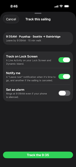
    Tap Track and choose how Ferry Good keeps you posted. Put the sailing on your Lock Screen, get a Leave now notification when it's time to go and another if WSF cancels the sailing, and, on iOS 26 and later, set an alarm that rings even if your phone is silenced. Ferry Good remembers your choices for next time.

  5. It follows you to the Lock Screen

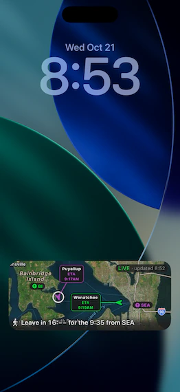
    The sailing you track moves to your Lock Screen and the Dynamic Island: the boats on a live map, a countdown to when you should leave for your sailing, and a badge that tells you if the data has gone stale. It updates live without you opening the app, and clears itself after your boat arrives.

  6. Swipe between your favorite routes

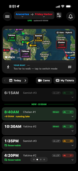
    Pick the routes you ride and each one gets its own page. Swipe sideways to move between them. On routes with more than two stops, like the San Juan Islands, tap the terminal names at the top to choose where you're leaving from and where you're going, or tap the arrows to flip direction.

  7. Route-specific alerts right at the top

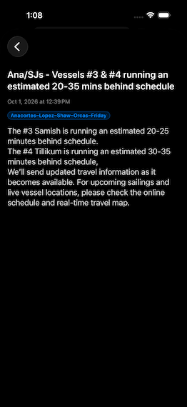
    When Washington State Ferries posts a service alert for your route, it shows as a banner at the top of that route's page. Tap it to read WSF's full notice, or close it once you've seen it. The bell keeps your recent alerts in one place, and you can turn on notifications for the routes you choose.

  8. Tap any vessel to get more details

    Tap a boat on the map to see which way it's going, when it's due in, its speed in knots, its heading, and, where WSF reports it, the car space left on its sailing. A label tells you whether it's underway or at the dock, and the card shows when the position was last updated.

  9. Vehicle reservations are one tap away

    On routes that take vehicle reservations, the schedule shows which sailings you can still book and which are full, for today and the days ahead. Open a sailing and tap Reserve a spot. Set your vehicle size once and it's used every time.

  10. The booking form, filled in for you

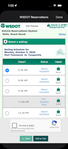
    Ferry Good opens WSDOT's reservation page inside the app and fills in the form: your terminals, the date, your vehicle size, and the sailing you tapped. You pick up at the last step. Signing in, the captcha, and payment stay between you and WSDOT.

  11. One tap to see the traffic at your terminal

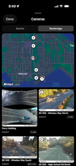
    Tap Cams to see the live traffic cameras at your terminal: the holding lanes, the ticket booths, and the roads leading in, depending on the terminal. A map shows where each camera sits, and you can switch between the terminals on your route. It's the fastest way to see how long the line is before you leave the house.

  12. Your routes, in your order

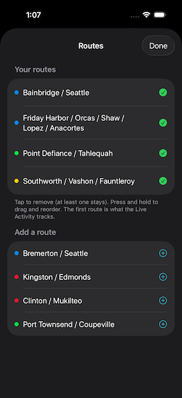
    Open Routes in the menu to choose the routes Ferry Good shows. Tap one to add or remove it, then press and hold to drag your routes into the order you want to swipe through them.

  13. Every ferry in the fleet, live

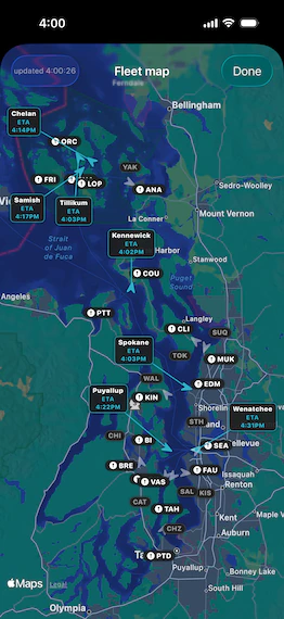
    The fleet map shows every Washington State ferry in service, across the whole system. Tap a boat to see which terminals it's running between, its speed in knots, and when it's due in. Positions come live from WSDOT's GPS feed, and the boats glide across the map as they move.

Built by people who have missed the boat

01 · Position

Watch the boat, not the timetable

Ferry Good tracks every boat live, straight from WSDOT's GPS feed. It knows where the boat for your sailing is right now and how long it usually takes to unload and reload at the dock, so it can work out when your sailing is likely to leave. When that's three minutes or more behind the schedule, you'll see the likely time in amber instead of relying on the printed one.

02 · Capacity

Know if you'll fit

For today's sailings, Ferry Good shows how many car spaces are left out of the boat's total, using WSF's terminal counts. The number updates live as cars drive on. On reservation routes it also tells you whether a spot can still be booked. Deck looking tight? Walk on, or pick a later sailing with room. WSF doesn't report car space on every route, including Fauntleroy, Vashon, and Southworth.

03 · Alerts

Leave at the right time

Your leave time starts from when the sailing is likely to leave, not when it's scheduled. Ferry Good takes off your walk, bike, or drive time from Apple Maps, time to get aboard (5 minutes on foot or by bike, 12 in a car), and any extra margin you choose. Track a sailing to get a Leave now notification, or on iOS 26 and later an alarm that rings even on silent. Want to see the line? The route's WSDOT terminal cameras are one tap away.

About

Made on this water

Ferry Good started as a group text. Six of us, all commuting across Puget Sound, all trading the same messages every afternoon: is it running late, is the deck full, should I leave now or eat dinner first.

The official schedule tells you when a boat is supposed to leave. It doesn't tell you about the sailing pulled for crew shortage, or the line at Fauntleroy stretched four blocks up the hill. We built the app we wanted on those evenings — one screen, honest answers, no digging.

We're a small team on both sides of the Sound. We ride these routes ourselves, most days, and we fix the things that annoy us first.

Your ferry
Every WSF route
Updates
Live
Sign-up
None
Free trial
7 days

Catch the next one

Try Ferry Good free for a week. Nothing to set up — open it and your route is already there.

Download on the App Store Want it onAndroid?

Scan with your iPhone's camera to get Ferry Good.

Ferry Good is an iPhone app for every Washington State Ferries route: Seattle–Bainbridge Island, Seattle–Bremerton, Edmonds–Kingston, Mukilteo–Clinton, Port Townsend–Coupeville, Fauntleroy–Vashon–Southworth, Point Defiance–Tahlequah, and Anacortes–San Juan Islands. It is independent and not affiliated with WSDOT or Washington State Ferries. Ferry data comes from WSDOT's public feeds.

Android

iPhone only, for now

Ferry Good is an iPhone app today. If you'd use it on Android, leave your email. That tells us how many riders want one, and we'll let you know if an Android version is on the way. We won't use it for anything else, and every email has an unsubscribe link.

The app itself never asks for your email. How we handle the list